Setup Menus in Admin Panel

Tropical Deserts and Arid Environments

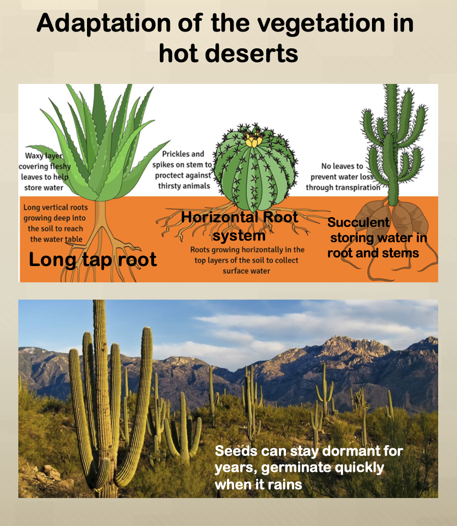
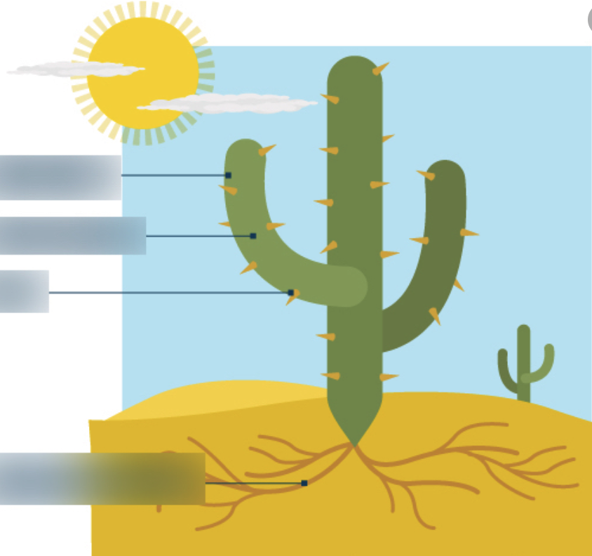
Hot Desert: it is the driest biome. Some deserts, such as the Sahara, get less than an inch of rainfall in an entire year. To conserve water, desert plants have very tiny leaves or no leaves at all, transferring the work of photosynthesis to their trunks or stems. That’s why cacti have green “trunks.” Saguaro cactus is the state flower of Arizona, USA. Its thick stem with waxy skin and spines can expand to store water. Desert animals also have to deal with high temperatures and minimal water supplies. Typically, they are nocturnal, hiding out in burrows during the day to beat the heat. Some animals, such as the desert tortoise, go into “estivation” in their burrows during the hottest part of the year. Estivation is the desert version of hibernation when the animal’s pulse and breathing slow down dramatically so that they don’t need to use much water or energy. Click here to read more on Sahara

Click Here to look at the amazing photo gallery of National Geographic on Sahara desert

Your Tasks

Step1. Colour (yellow) the hot deserts of the world. Remember their names.

Step2. Superimpose Equator, Tropic of Cancer and Tropic of Capricorn on the blank world map.

Step3. Locate the hot deserts that you have learned on the map.  

Step 4. Identify the mountains creating Rain-shadow effect to each of your identified hot desert. Write the names of the mountain. 

Step 5. Write the names of oceans on your map. Identify the cold ocean currents near the hot deserts creating high pressure and thereby reducing the water vapour content in the air. 

Step 6. Draw the Hadley cell circulation on your map. 

Step 7. Explain rain shadow effect and adiabatic heating of the airmass using a diagram.

Note: Adiabatic heating occurs as a mass of air descends downslope from a mountain range towards the lower atmosphere. The  descending air encounters increasing atmospheric pressure. Compression of the air mass is accompanied by an increase in temperature. Descending airmass also warms up due to ground radiation.

Tasks:

Observe the above diagrams and maps, discuss in groups and try to answer the following questions 

QuestionsTerminologies/concepts to be used in the answerExtra references
State one similarity and one difference between the location of the Kalahari Desert and the location of the Namib Desert.Diagram based locational reference such as latitude (Tropic of Capricorn), Inland or coastal location, extension (using the scale)
Explain why the Namib Desert and the Great Australian desert do not receive much rainfall. 1. Close to Tropic of Capricorn (Hadley cell circulation and its impact).
2. High air pressure and Cold ocean current.
3. Descending air and increasing water holding capacity
4. Rain-shadow effects
5. inland-continental location and prevailing wind.
Why deserts, such as the Kalahari, have a high diurnal (daily) range of temperature?High diurnal (daily) range means: High daytime but cold night temperatures due to
1. Lack of clouds allow high insolation during day.
2. Lack of clouds allows heat to escape at night.
3. Inland so no moderating influence of sea.
On the given map, locate tropical rainforest (equatorial climate) using green color and the locations of the hot deserts using yellow color.

What do 'a' and 'b' signify on the given map?
Equator
Tropic of cancer and tropic of Capricorn
35 degree North and South of Equator
Refer to the given Climate graph of the Californian hot desert, describe the characteristics of the hot desert climate (refer to the statistics). State the average trend
Highest and lowest variations (mention the graph data with units)

Setup Menus in Admin Panel

Login

Create an Account Back to login/register