
Prev
Next
Why does earthquake happen?
Earthquakes are associated with all types of plate boundaries. Earthquakes occur when tension is released from inside the Earth. Plates do not always move smoothly alongside each other and may get stuck. When this happens pressure starts to build up. When the accumulated pressure (energy) is eventually or abruptly released, earthquake tends to occur. While the fault rupture can be visible at the surface, the actual displacement may occur at a considerable depth as deep as 500 km beneath the surface in case of a subduction zone. Earthquake may also develop from the movement of magma or due to sudden ground subsidence.
| Terminologies | Definition of the terms |
|---|---|
| Earthquake | Earthquakes are sudden, violent shaking or vibration of the earth crust produced by the shock waves resulting mainly from a sudden displacement along a fault. |
| Quasi-natural earthquakes | Man made causes like nuclear testing, building of large dam or reservoir, oil drilling, coal mining may cause earthquakes. |
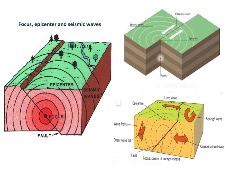
| Focus or hypocenter | The place beneath the ground where the earthquake originates due to sudden release of energy is called the focus. |
| Epicenter | The point on the Earth’s surface directly above the focus is called the epicenter. The strongest shocks and crustal vibration are often felt on at the epicenter. |
| Aftershocks | These are the series of small earthquakes that follow a major earthquake. If the initial earthquake is strong, then the aftershocks can also be very strong. Aftershocks redistribute stress at the fault zone. |
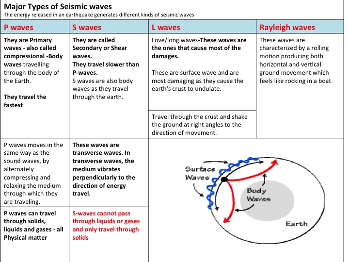
| Seismic waves | The energy released in an earthquake generates different kinds of seismic waves. These waves travels outward in widening circles, like the ripples produced when a stone is thrown into a pond, marked by diminishing amplitude with increasing distance from the focus. |
| Earthquake magnitude-Richter scale | The most commonly used magnitude scale is Richter scale, devised in 1935 by Charles Richter. The scale is easy to use but not appropriate for comparing very large earthquakes with magnitude 7 and higher. There is no upper limit to this scale. The scale is logarithmic means that there is a 10 fold increase every time the scale increases by 1. So a scale of 2 earthquake on the richter scale is 10 times more powerful than scale 1 and a scale 3 is 10 times more powerful than scale 2 and 100 times more powerful than scale 1. Moment magnitude scale is now widely used to describe the size of large earthquakes. It combines several parameters like movement on the fault, rock strength, size of the rapture etc. |
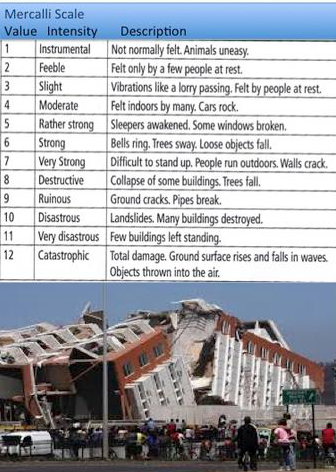
| Earthquake Intensity- Mercalli scale | Mercalli scale, originally devised by Italian geologist Giuseppe Mercalli in 1902 and was later modified in 1956. The scale varies from 1 to 12 categories based on observed effects and damages.It uses subjective description of the resulting damages. |
| Isoseismal lines | Lines of equal intensity drawn on a map around the epicenter of an earthquake. |
| The affect of an earthquake depends on numerous human and physical factors | The depth of the earthquake focus and the magnitude of the earthquake (energy released) The duration of the earthquake The local geology (soft or hard rock, solid or cracked rock) The location of the epicenter (in a rural or urban area) The population density around the epicenter. The building design and hazard mapping near the epicenter. The time of day (earthquakes at night might trap people in their houses, earthquakes during dinner time might trigger more fires). Economic condition and preparedness of the population (evacuation routes, emergency services, etc.) Secondary hazards such as liquefaction or generation of a Tsunami. |
| Secondary hazards associated with Earthquakes | Secondary hazards are caused or triggered by the primary hazard. Secondary hazards may sometimes be more dangerous than the primary hazard. Earthquakes can cause several secondary hazards, that can often be more damaging than the primary hazard. Tsunamis Dam failure Landslides Fires Disease Liquefaction - process by which water-saturated, unconsolidated sediments are transformed into viscose substance that acts like a liquid. Its effect on structures and buildings can be devastating. |

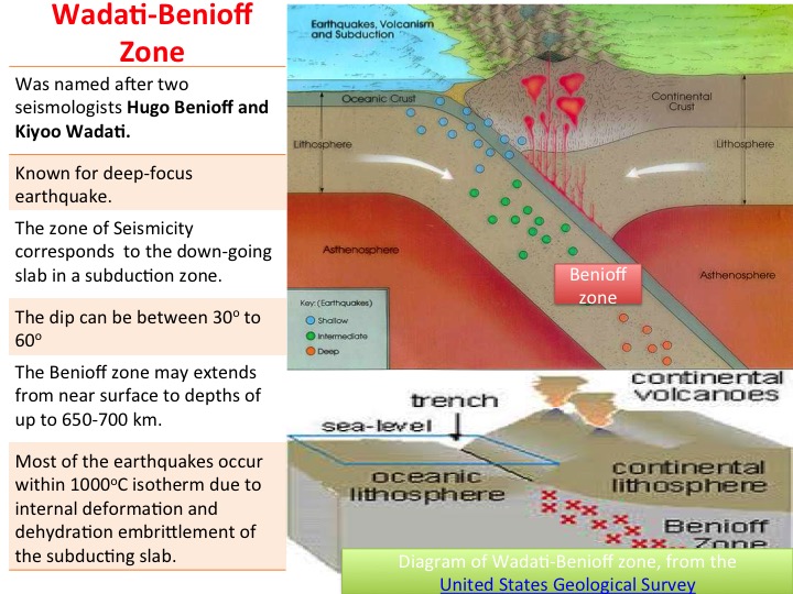
Earthquakes can be classified according to the depth of their focus. Three broad categories are recognized:
Shallow focus earthquake causes the greatest degree of damage and account for approximately 75% of all earthquake types. Deep focus earthquakes are generally associated with plate margins (Benioff zone) where the oceanic plate is forced under the continental plates in the process of subduction. Shallow focus earthquakes are generally located along constructive and conservative boundaries.
Horizontal distribution
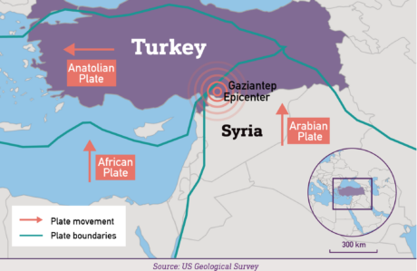
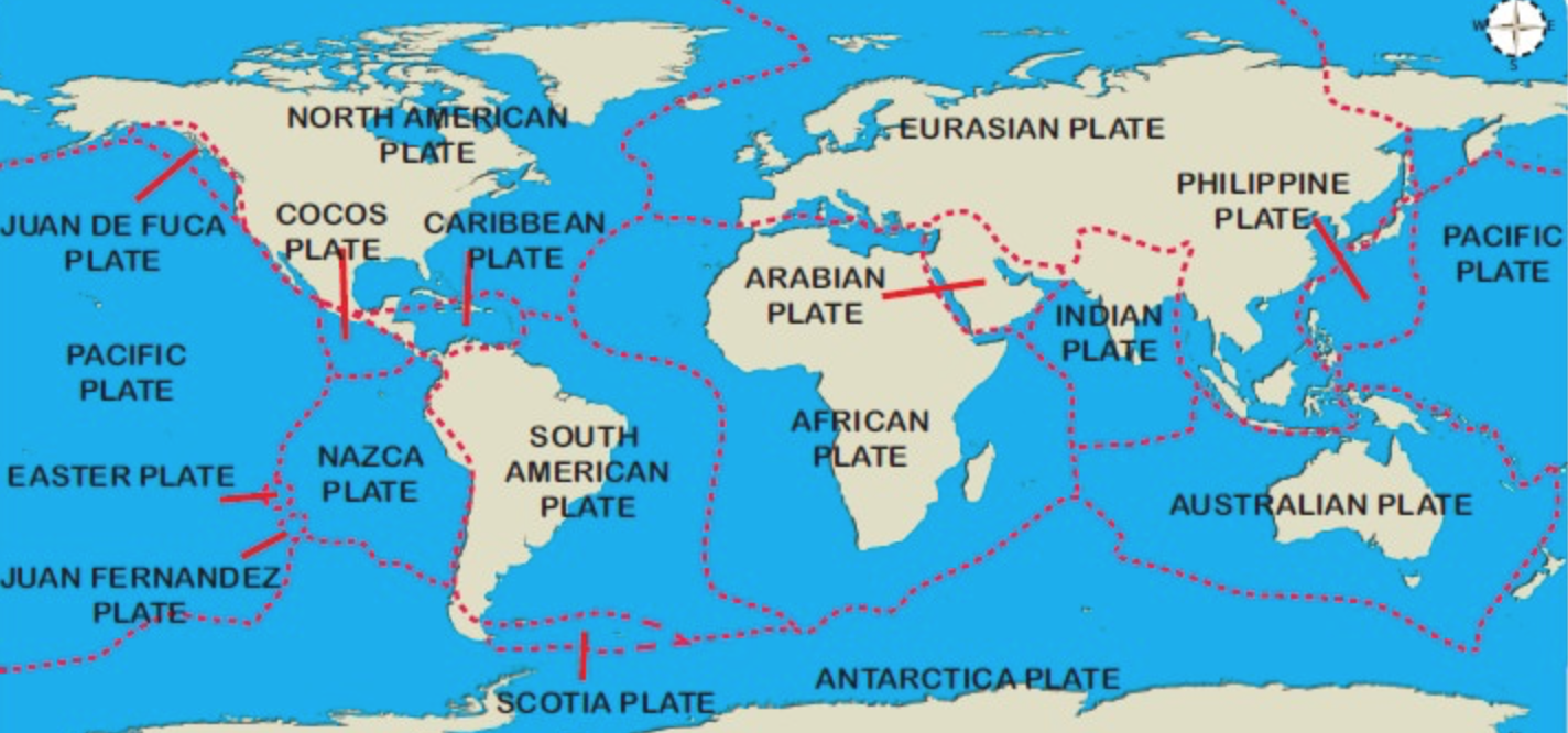
Earthquakes occur along the plate margins. The friction and pressure that build up where the plates meet are the causes of earthquake. Destructive margins: The pressure resulting from the subjecting plate and its subsequent melting can trigger strong earthquake as the pressure is released periodically. Conservative margins: Where the plates slide past each other tend to get trapped for a period of time causing stresses and pressure to build. Sudden quick release of the pressure and movement along the fault line may results in powerful earthquake. Constructive margins: Earthquake’s tends to be less severe as the friction and pressure caused by the plates moving apart is much less intense than the other two plate margins.