| Terminologies | Explanations | Additional information |
|---|---|---|
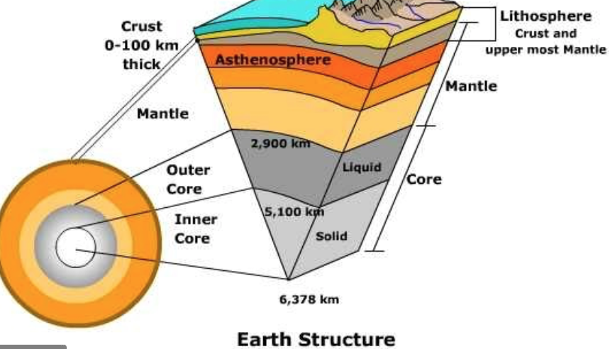
| Earth's Interior | Crust: The outermost layers of Earth, bounded by the atmosphere above and the asthenosphere below. It is the thinest layer. Mantle: The mantle lies between the dense, super-heated core and the thin crustal layer above. The mantle is about 2,900 kilometers thick, and makes up 84% of Earth’s total volume. It is composed of mostly silicates rocks (silicon and oxygen structure). Core: Unlike the mineral-rich crust and mantle, the core is made almost entirely of iron, nickel and sulfur. 90% of the sulfur on Earth is found in the core. It is the hottest part of our planet. It is also very dense layer. | The asthenosphere is in viscous (semi-solid) state. Read more from the National Geographic Society |
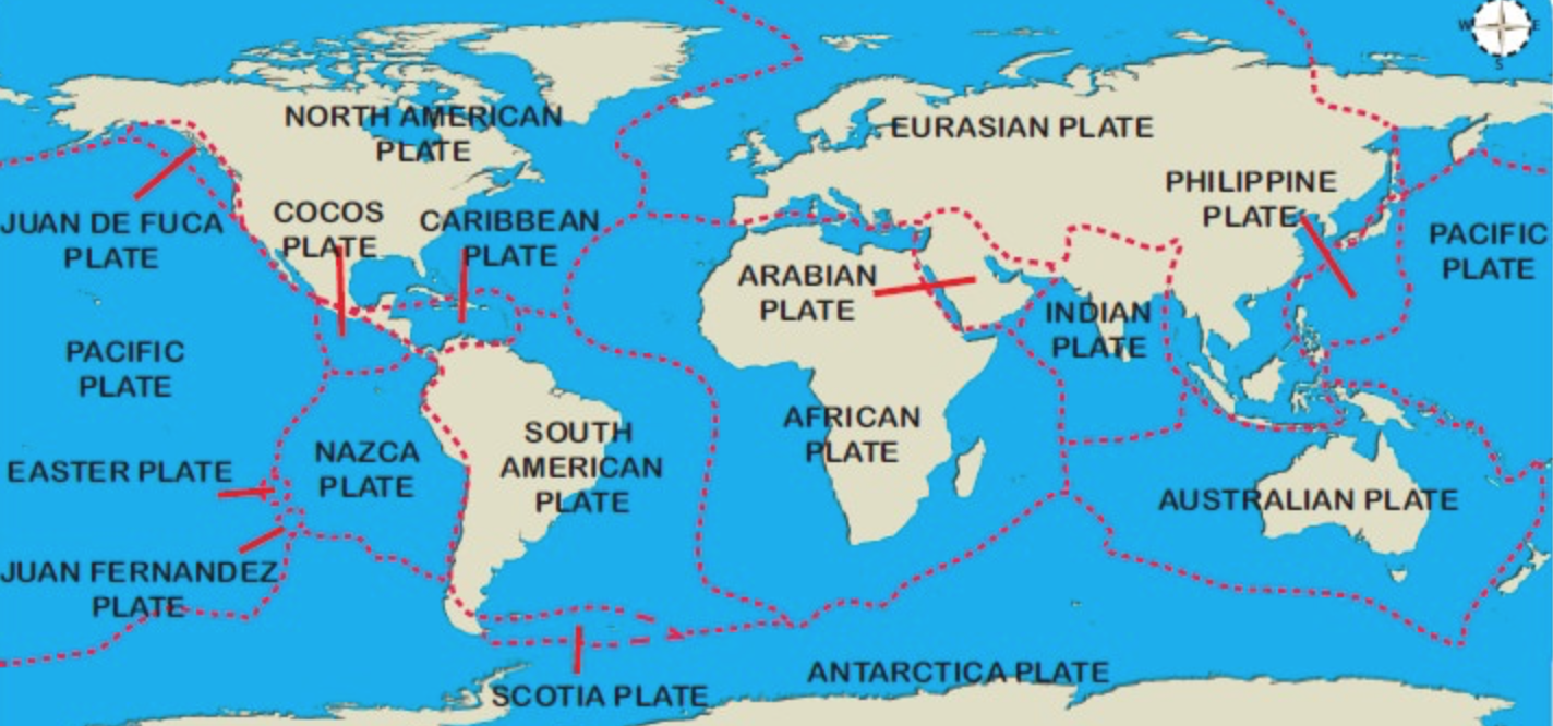
| Major and Minor Plates | Earth's lithosphere is divided into a series of major and minor plates. These plates are actually crustal layers moving over the asthenosphere (outer layer of mantle) due to mantle convection current. Eurasian plate, Indo-Australian plate, North American plate, South American plate, Pacific plate, African plate and Antarctic plate are the major plates. Arabian plate, Caribbean plate, Cocas plate and Scotia plate are the examples of minor plates. Plates move at the rate of 2 to 3 centimeters per year on a average. | Lithosphere is the solid outer layer of the Earth. Refer: National Geographic Society info here. There are two types of lithosphere: oceanic lithosphere and continental lithosphere. Oceanic lithosphere is associated with oceanic crust, and is slightly denser than continental lithosphere. |
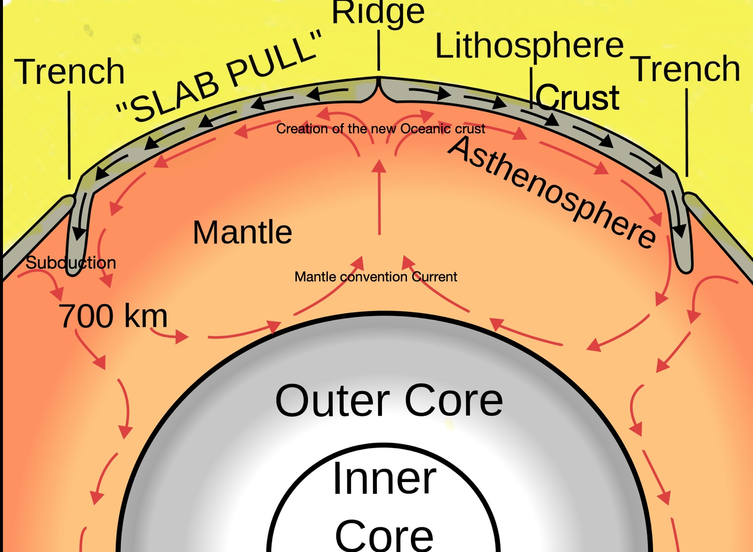
| Mantle Convection Current | The movement of tectonic plates is possible due to the thermal energy circulation in Mantle. The heat released from the core helps to drive mantle convection. | Click here to draw the diagram of the mantle convection cell below the oceanic curst at the mid-oceanic ridges. |
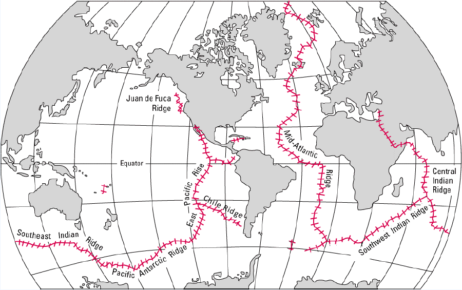
| Mid Oceanic Ridges | The massive mid-ocean ridge system is a continuous range of underwater volcanic mountains formed by the diverging plates at the middle of the oceans. These are the most prominent plate boundaries and the most active volcanic features on Earth. Deep rift valleys are located at the center of the system, from which magma flows and forms new oceanic crust. | Click here to refer the distribution of the mid-Oceanic Ridge system. |
What is a tectonic plate? Click here: To refer from National Geographic
Earth’s outermost layer is fragmented or into several large and small solid slabs, called lithospheric plates or tectonic plates that are moving relative to one another. A tectonic plate is a rigid lithospheric slab of the fractured crustal surface of the earth floating on the semi-molten asthenosphere. The theory of plate tectonics explains the global distribution of earthquakes, volcanoes, fold mountains and rift valleys. To understand why volcanoes and earthquake happen, it is necessary to understand what goes on beneath the surface of the earth. Plate tectonics is a relatively new theory and it wasn’t until the 1960’s that Geologists, with the help of ocean surveys, began to understand what goes on beneath our feet.


Prev
Next
Source: https://upload.wikimedia.org/wikipedia/commons/8/8a/Plates_tect2_en.svg

Background Knowledge
| Layers of the Earth | Characteristics | Thickness and temperature |
|---|---|---|
| Crust (i) Continental crust, which carries land, made up of mostly low density granite (ii) Oceanic crust, which carries water, made up of mostly basalt | Outermost layer of the earth Relatively thin Made up of low density light weight material Split into several plates floating on the semi-molten upper Mantle. | 0 to70 km thick, continental crust is thicker and lighter than oceanic crust. |
| Mohorovicic Discontinuity or Moho | The boundary between crust and mantle | |
| Lithosphere | Consist of the Earth´s crust Hard, rigid, fragile surface layer of the planet. | |
| Mantle (i) Upper mantle or Asthenosphere (ii) Lower mantle | Comprises 84% of the Earth’s volume and 67% of its mass, Hot material upwells, while cooler and heavier material sinks downward.Hot and partially molten layer of the Earth which underlies the lithosphere.Most magma that erupt at the surface as lava are derived originally by melting of the mantleis almost exclusively solid | It has a thickness of approximately 2,900 km. temperatures range between 500 to 900 °C |
| D layer and Gutenberg discontinuity | Core-mantle boundary | |
| Core (i) Outer core (ii) Inner Core | Inner most layer of the Earth consist of predominantly Iron, Nickel and SulfurOuter core is a layer of slow-moving liquid metal. It generates electrical currents as it flows and these create Earth’s magnetic field.Inner core is a solid mass of hot metal reaching over 5000 °C. | Up to 5150 km Temperatures of up to 5,500°C. Up to 6378 km from the surface |
Background knowledge: the forerunners of the Plate tectonic Theory
- Theory of continental drift by Alfred Wegener in 1912
- Sea floor spreading by Harry Hess in 1960s
1. Continental drift theory of Alfred Wegener (1912)
Wegener suggested that around 300 million years ago all the continents were joined together as a single supercontinent called Pangaea, surrounded by a primeval ocean called Panthalassa. The continents have since moved away or drifted apart from one another.
Why did Wegener talk about continental drifting:
- The similarity in shape of the edge of the continents, as if they can be fitted together like the pieces of a jigsaw puzzle
- The presence of fossils of plants such as Glossopteris, a fossil fern whose spores cannot cross wide oceans and animals who cannot swim across the wide oceans, now can be found widely-separated continents of Africa, Australia, and India
- The presence of glacial deposits near the equator. The coal and oil reserves found in Antarctica suggest that this area was once in a different climatic zone.
- The similarity of rock sequences and geological structures on different continents.
Why his theory was rejected at that time:
- The mechanism for the movement which he mentioned was a combination of centrifugal force and the gravitational pull of the moon.
- Physicists quickly proved that these forces were insufficient to move the continents and at that time little was known about the nature of the sea floor.
2. Sea-floor spreading by Princeton geologist Harry Hess in early 1960s
Basaltic magma from the mantle rises up to create new ocean floor at mid-ocean ridges and then moves apart and subsequently destroyed in subduction zones (recycled back into the mantle) to accommodate the increasing size of the oceanic crust (at that time it was not known clearly)
Supporting Arguments:
- Age of the seafloor rocks
- Near the mid-oceanic ridges, the basaltic rocks of the sea floor are much younger than those found towards the continental shelves at the edge of the oceans.
- Paleomagnetism
- Study of the Earth’s magnetism and reverse polarity suggests that the rocks have been formed at the ridge and then moved away in both directions. There is a parallel pattern of magnetism in the rocks of the sea floor. As magma cools and solidifies, the iron bearing elements within it are magnetized in the direction of the earth magnetic field. There have been many reversals of the earth’s magnetic field over time and the pattern of the rock alignment on the sea floor relates to this alternating pattern of polarity.
Oceans cover 70% of Earth’s surface. Deep sea remains almost entirely unknown. An average depth of 4 kilometres, makes the deep sea the largest of all habitats. Ocean floors are the youngest crust of the planet created through the process of seafloor spreading. Seafloor spreading occurs along mid-ocean ridges (large mountain ranges rising from the ocean floor). New ocean floor is created at the mid oceanic ridges as molten materials or magma from the earth’s mantle rises and push apart two divergent plates (slabs of the crust). Therefore, the newest, thinnest crust on Earth is located near the center of mid-ocean ridge.


Prev
Next
Draw: Mantle convection current
Refer: https://www.brainkart.com/article/Convection-Cell_33772/
Plate Tectonic Theory by Tuzo Wilson, W. J. Morgan, McKenzie and Parker in 1965
Mechanism of plate movement:
- The Earth’s surface is made up of a series of large rigid crustal slabs called plates, floating on the semi-molten material of the asthenosphere. These plates are in constant motion in relation to each other, moving typically at rates of a few centimeters per year. Basaltic magma from the mantle rises up to create new ocean floor at mid-ocean ridges and then moves apart and subsequently destroyed in subduction zones (recycled back into the mantle) to accommodate the increasing size of the oceanic crust. The most likely cause of plate movement is the Mantle Convection currents that generate in the asthenosphere push the plates in different directions. The source of heat creating the convection current cells is a combination of radioactive decay in the core and the residual primary heat of the Earth. The convection currents cause the magma to circulate that pulls the lithosphere apart. Plates are hottest near the mid oceanic ridges and cool down as the move away. As the plate materials cool down, density increases so it starts sinking into the molten rock beneath and is easily dragged downwards into the subduction zone. This is known as slab pull means the subducting slab pull on the rest of the plate.
Prev
Next
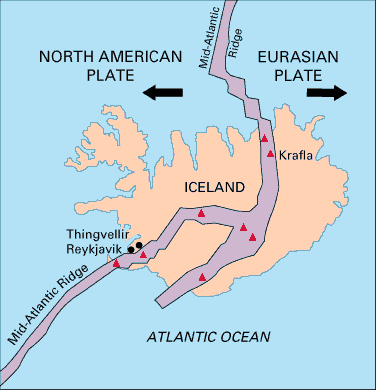
Divergent and Constructive Boundaries
Where plates are moving away from each other. The movement is due to divergence of two cenvection cells, which brings magma from the asthenosphere towards the surface
Types of divergence possible:
- Divergence of two oceanic crust as is happening along the mid-Atlantic ridges.
- Divergence of two plates of continental crust as is happening in East African rift valley.
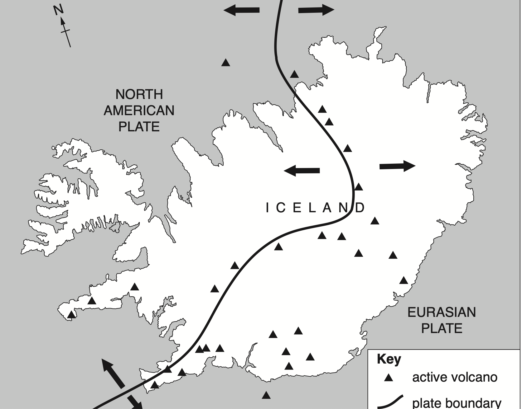
Example of Iceland:
The divergence of Eurasian plate and the North American plate at the Mid-Atlantic Ridges is an example of a constructive margin.
Prev
Next
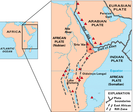
East African Rift System: Divergent continental margin
The East African Rift System is a 50-60 km wide active volcanic and faulting zone that extends north-south in eastern Africa for more than 3000 km ( app. 1800 miles) from Ethiopia in the north to Zambezi in the south. It is a rare example of an active continental rift zone, where a continental plate is attempting to split into two plates, which are moving away from one another. A new oceanic curst is in the process of formation as molten magma from the mantle rises to fill any possible gap between the two plates. The African Plate is in the process of dividing into two new tectonic plates called the Somali Plate and the Nubian Plate.
Prev
Next
Convergent boundaries or Destructive margin
Destructive plate margins occur where two plates converge due to the existence of the descending limbs of convection cell currents in the asthenosphere beneath the lithosphere. This type of margins are common where oceanic crust meets continental crust. For example, convergence of Nazca plate beneath the South American plate. The more denser crust is subducted down into the asthenosphere beneath the less dense crust.
Types of convergence and it’s effects
1. Oceanic crust meets Continental crust
- Oceanic crust is denser than continental crust. The continental crust, being more buoyant, is not subducted but is uplifted, buckled and folded and forms a range of fold mountains such as the Andes.
- The subducted plate is heated and eventually melts under pressure at about 100 km below the surface. This melted material rises up through any lines of weakness and may create volcanic mountains. It may also cool and solidify beneath the surface forming intrusive igneous features called batholiths and other granite structures. High magnitude earthquakes are common.
Example: Nazca Plate moving under the South American Plate
- The Oceanic Nazca plate is moving towards east at a rate of app.12 cm per year and converges with and then subducts beneath the continental South American plate, which is moving west at an average rate of 1 cm per year. The Peru-Chile trench reaches the depth of 8000 meters at the zone of subduction. Earthquakes are often of high magnitude.
- The Andes, a chain of fold mountains rising nearly 7000 m above the sea level, has been formed as the continental crust has been buckled and lifted up. Volcanoes such as Cotopaxi, occur along the mountain chain.
2. Oceanic crust to another oceanic crust
- Where two plates of oceanic crust come together
- Subduction still occurs, as one plate is likely to be older and denser than the other.
- Volcanic activity leads to a formation of a chain of volcanic islands, known as island arc such as Mariana and Guam island chains at the convergence of Pacific and Philippines plate.
Example: Pacific plate and Philippines plate colliding at the Mariana trench. At the Mariana Trench subduction zone, the down-going plate is the Pacific Plate, and the overriding plate is the Philippine Sea Plate.
Creation of volcanic arc:
As the down-going plates plunge even deeper into the Earth’s mantle, fluids that continue to be released cause melting in the surrounding hot mantle at depths from 70 to 100 kilometers. This generates magma (molten rock) that rises up toward the surface and feeds a chain of volcanoes parallel to the trench. This chain is called volcanic arc.
Collision Margin: Continental to Continental crust
- The convergence of two plates of continental crust is known as collision margins.
- No subduction occurs, as both plates are buoyant and of low density.
- Intervening oceanic sediments trapped between the two converging plates are heaved upwards, resulting in the formation of fold mountain ranges.
- No volcanic activity is found in this type of margin as no crust is being destroyed by subduction.
- Deep focus earthquakes often occur with limited surface impact.
Example:
Himalayas: Indo-Australian plate collides with the Eurasian plate.
Alps: African plate and Eurasian plate (still a tiny bit of ocean is left as the Mediterranean sea)
Case of Himalayas:
- The Indo-Australian plate is moving northwards at a rate of 5 cm per year and collides with the Eurasian plate, which is moving southeast-wards at a slightly slower rate.
- Prior to their collision, the two landmasses were separated by the remnants of the Tethys sea. Tethys sea originated 300 million years ago at the time of break up of Pangaea.
- Himalayas formed as the two plates collided, the continental crust including the shallow sea sediments have been buckled and lifted up.

Prev
Next
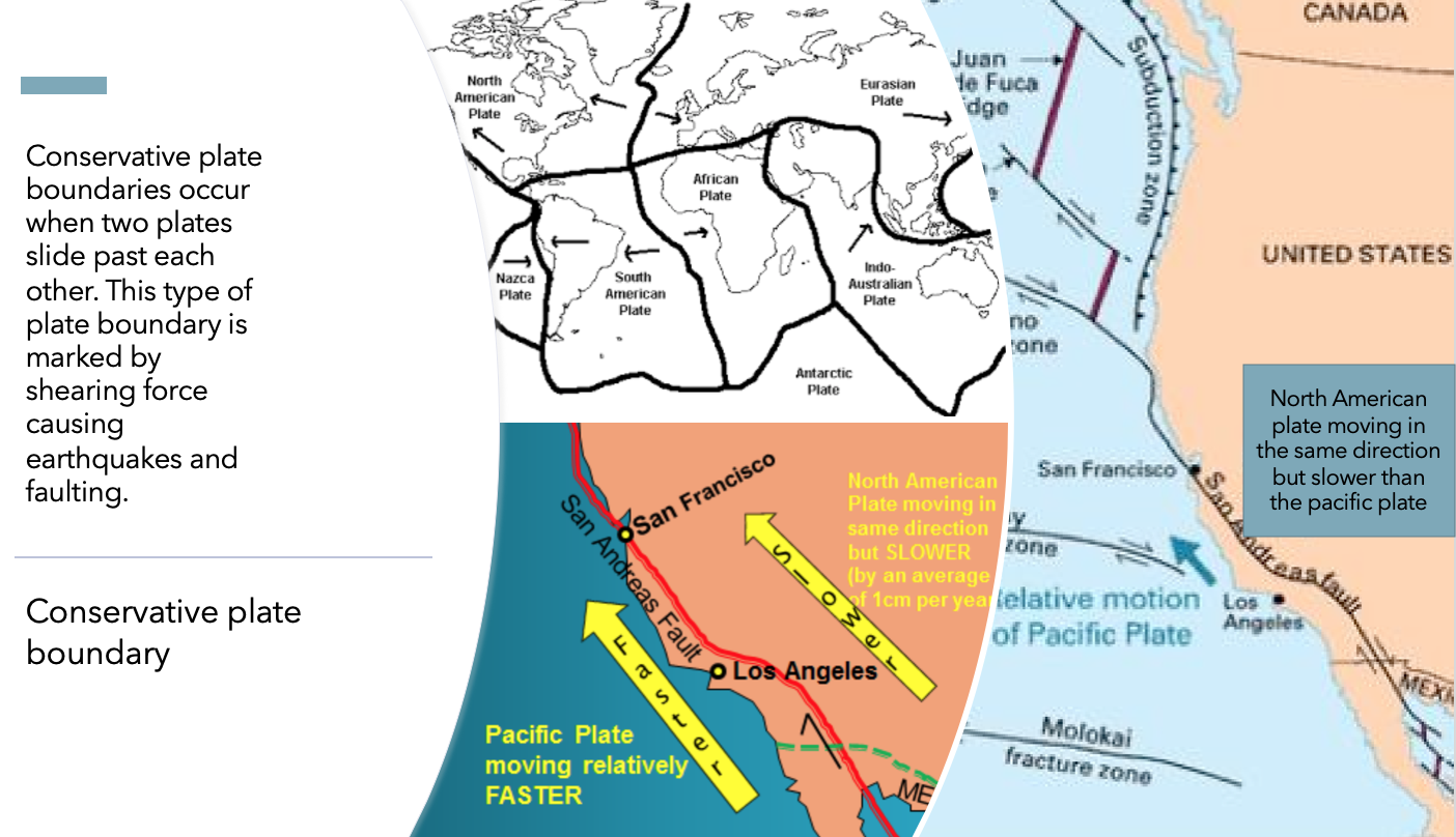
Conservative Boundaries
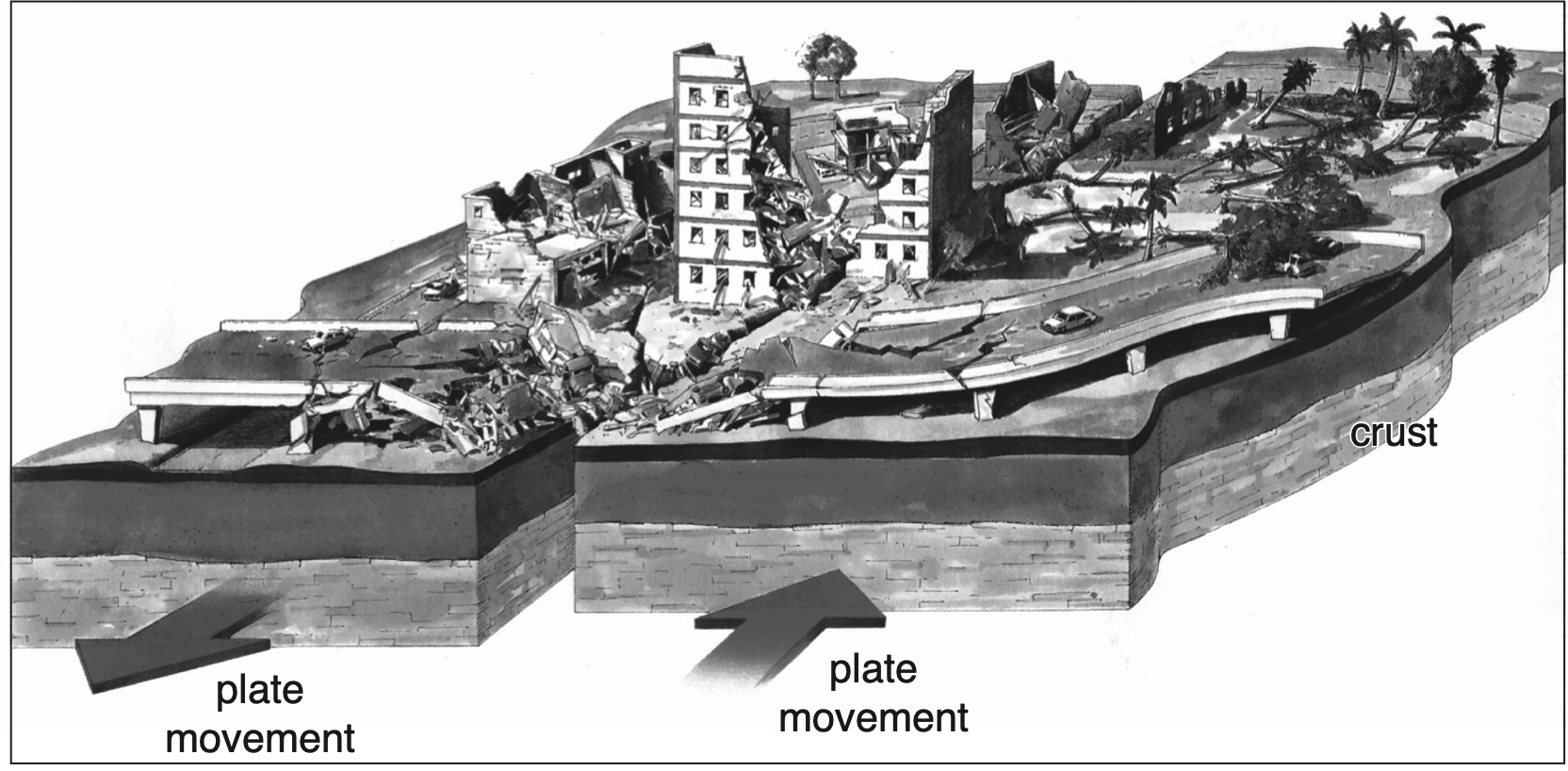
- Conservative margin occurs when two plates laterally glide past each other. Like the collision zone boundary, no volcanic activity is found here. Volcanic activity is normally not present because the typical magma sources of upwelling convection current or a melting subducting plate are not present here. Shallow focus high frequency-low magnitude earthquakes are common along this type of margin. The earthquakes are usually shallow because they occur within and between plates that are not involved in subduction. Major earthquake events may take place after a significant built-up of pressure, typically when high levels of friction restrict movement of the crust along fault lines. Most of the lithospheric plates have a constructive margin at one edge and a destructive margin at other. Conservative margins make up the other two sides. Volcanoes are generally absent along strike-slip boundaries such as the San Andreas Fault.
Transform Fault : A transform fault is a special type of strike-slip fault commonly found along the conservative plate boundary. A strike slip fault is one in which the adjacent blocks are displaced laterally or horizontally relative to each other or parallel to the line of the fault as a consequences of shear stresses.These faults accommodate the relative horizontal slip between two tectonic plates. Transform faults are also common along the edges of the plates in mid-oceanic ridge regions. The lateral displacement along transform faults often ends or changes abruptly. Transform faults are locations of recurring earthquake activity and faulting. Example: Best known conservative boundary is between the Pacific plate and the North American plate along the coast of California.
Prev
Next
Hotspots Volcanism
Hot spots are the places where plumes of magma rise up from the mantle if the crust is thin or weak, even though they are not necessarily near a plate margin. Lava may build up over time above the present day sea level, giving rise to a volcanic island.
Mantle convection and hotspots volcanism:
Heat constantly flows out of the Earth’s core at the base of the mantle, causing the semi-molten mantle to circulate slowly and carrying the heat outwards by convection. Convection plays a major role in driving the movement of the tectonic plates at the top of the mantle. The pattern of convection is not fully understood. Geophysicists have recently argued that the mantle convection occurs in two layers involving a deep layer circulation, which is largely separated from the rest of the upper-mantle convection. According to this model, streams of hot deep layer material from the core-mantle boundary flows upward as mantle plumes, creating hotspots. On the other hand, shallow upper mantle convection is responsible for mid-oceanic volcanism.
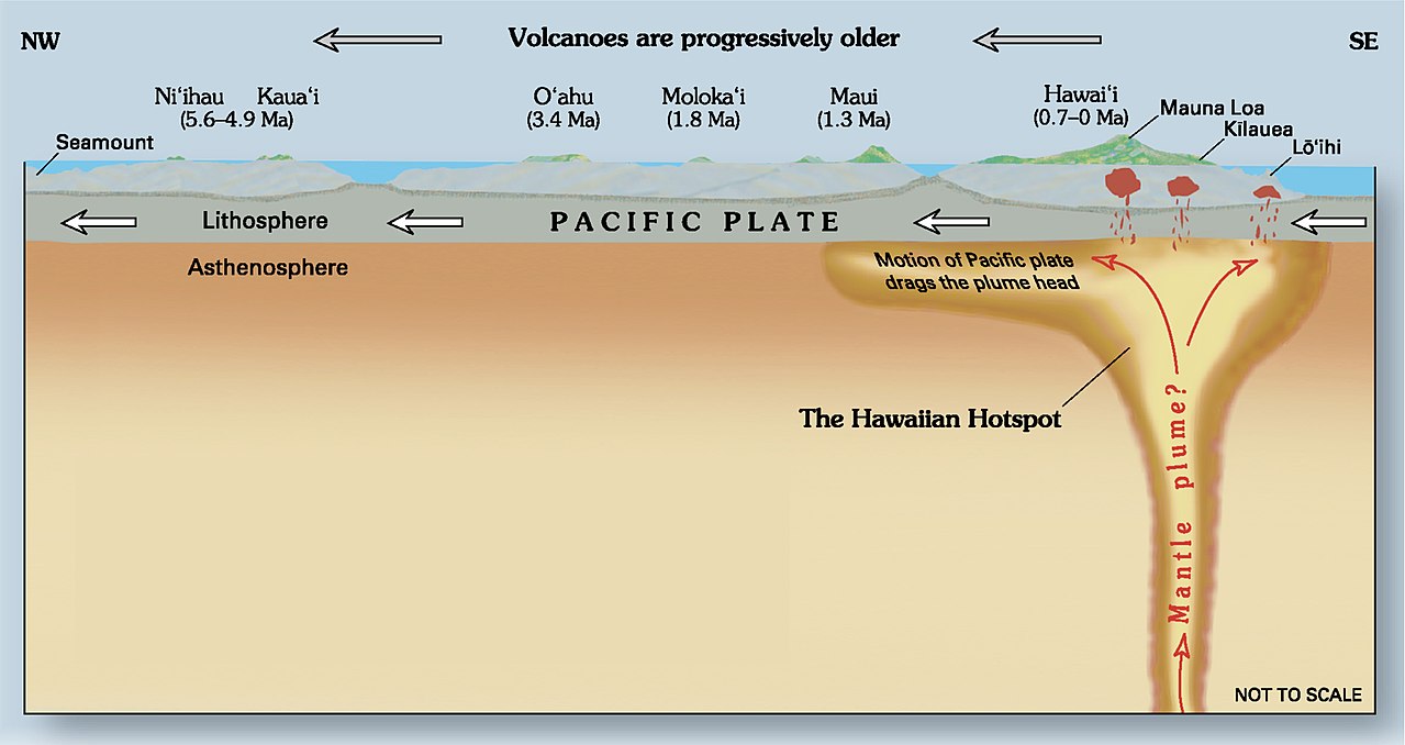
The Hawaiian Islands
The Hawaiian Islands are a chain of volcanic islands lying over a stable hot spot. The pacific plate has been moving over the hot spot for about 70 million years and a succession of volcanic islands and underwater volcanoes has formed over time. As the plate moved so the volcanoes have been carried away from the hot spot in a northwesterly direction, forming a chain of extinct under-water volcanoes called seamount. Kauai is the oldest of the main Hawaiian Islands now, having formed some 5 million years ago, with its volcano considered to be extinct and in the process of erosion. These extinct volcanoes are often eroded into flat-topped remnants called guyots, extending all the way to Aleutian Islands. At present the seafloor of nearly 20 miles to the southeast of Hawaii is an active volcanic area with periodic eruptions. This area is called Loihi and will be the site of the next Hawaiian Island in 10000 years. Most hotspots, are also known as “mantle plumes,” occur beneath oceanic plates. Yellowstone in U.S., however, is a good example of a hotspot beneath a continental part of a plate. Yellowstone caldera is well known for its bubbling fumaroles (vents from which volcanic gas escapes into the atmosphere) and hot water geysers like “Old Faithful.
Prev
Next
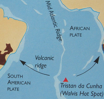
Tristan da Cunha: The Walvis Hot Spot
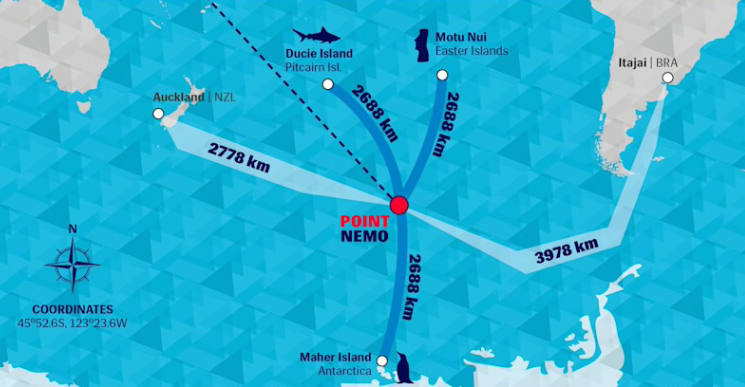
Tristan da Cunha is an active strato-volcano formed above a hot-spot around 400km east of the Mid-Atlantic Ridge. It is the most remote inhabited location on Earth. It is located nearly 2,800 kilometers from the nearest mainland, the Cape of Good Hope, South Africa. The nearest island St. Helena is around 2000 km. However, in terms of inaccessibility, the point farthest from land is Point Nemo, which is in the South Pacific, more than 2,500 kilometers from any land mass in all direction.

Prev
Next
Fun Learning
Level1: Earthquake Quiz
Level 2: Earthquake Quiz 2
Level 3: Multiple Choice Questions on Earthquake
L1 Volcano Quiz
L2 Volcano Quiz
L1.1 volcano quiz
National Geographic Quiz-whiz on volcano
ProProf. volcano quiz (32 questions)
Volcano jigsaw puzzle
Volcano types matching
Flashcards on volcano